Long range Tropical Storm forecasts
Tropical storm plots show statistics about the expected number of tropical storms and number of hurricanes/typhoons per basin over months 2-7 of the forecast period compared with climatology.
These plots are derived in a similar way to the equivalent plots used for the extended (monthly) time ranges, namely by counting the number of storms in the forecast ensemble, and then scaling the numbers multiplicatively so that the model forecast climatology is realistic when compared to observations. For the northern hemisphere basins, the scaling is based on a comparison of model with observations in a moving interval of the previous 10 years, which helps ensure that low-frequency variability in tropical storm numbers is adequately represented. For southern hemisphere basins, where such variability is not a problem and where sampling uncertainties are larger, the calibration uses the full period 1993 to the previous year. The scaling in both cases is based on the mean of the central two quartiles of data, thus reducing the impact of extreme seasons on the calibration. Observational data is taken from IBTrACS4, selecting the NHC and JTWC wind speed estimates to give consistency across basins. Forecasts are available for number of tropical storms, number of hurricanes/typhoons, and accumulated cyclone energy (ACE). Storms are allocated to the basin in which they first form, while ACE is allocated to the basin in which the storm is present at each point of its trajectory.
Fig8.3.4.3-1: To view Tropical Storm Frequency.
- On Charts page, enter Tropical Storm Frequency
- Click on Tropical Storm Frequency diagram - Long Range
- As desired select other base times, or Accumulated Cyclone Energy or Tropical Storm Frequency from drop down menu.
Fig8.3.4.3-2: An example of long-range (seasonal) forecast of Hurricane/Typhoon Frequency and Accumulated Cyclone Energy within several basins (e.g. Atlantic Ocean, Indian Ocean, etc) compared with climatology. Here the forthcoming tropical storm season in the western Pacific is forecast to be a little less active than normal, while being a little more active than normal in the eastern Pacific and the Atlantic. This product only represents the integrated total over the season and does not imply that intense typhoons or hurricanes will not actually occur.
Time-series of tropical storm statistics on the number of hurricanes/typhoons and statistics on the accumulated cyclone energy are also available for each basin. These show the latest forecast along with all previous forecasts/re-forecasts, and with the observed verification for previous years. The forecasts are shown as an ensemble mean for each year (in blue), plus and minus one standard deviation (green lines). If the forecasts were reliable, the observations would fall within this range about 70% of the time. The time-series plots also show the correlation and Root Mean Square Error, calculated over the verified forecasts shown. Calibration of past forecasts is always cross-validated, and uses either all other years (excluding the year being predicted), or the 10 years previous to the year predicted, depending on ocean basin.
Empirical Orthogonal Function (EOF) - based rainfall indices
Explanation of the derivation of the climagrams of rainfall indices available on Opencharts.
Indices of the large-scale distribution of monthly rainfall in the regions affected by the West African and South Asian monsoon were defined by means of EOF analysis. The two leading EOFs of monthly-mean rainfall anomalies from the GPCP (Global Precipitation Climatology Project) 2.5-deg. dataset have been computed in the following domains:
- West Africa: 0 - 20 N, 25 W - 27.5 E
- South Asia - Indian Ocean : 15 S - 30 N, 60 E - 120 E
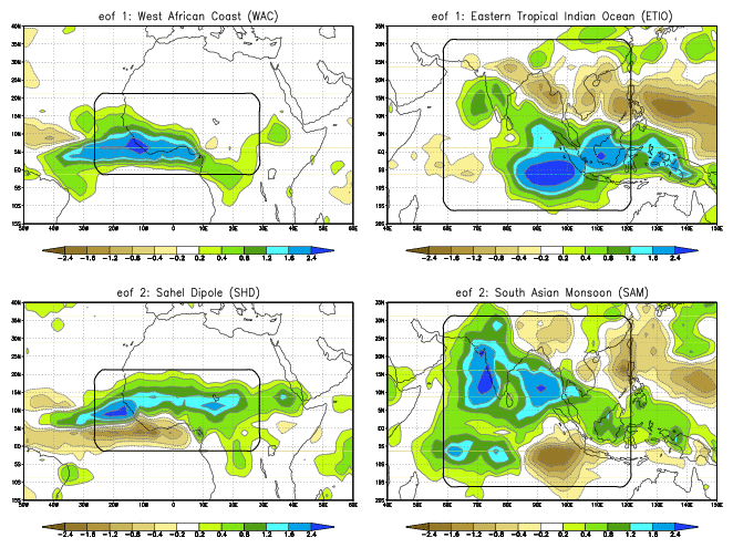
using June, July, August and September data from 1981 to 2005. The EOF patterns for the two regions are shown below, where the portion within the grey boundaries corresponds to the regionally-normalized EOFs (for continuity, regressions of rainfall anomalies onto the corresponding PC are shown over a larger domain)
Fig8.3.4.3-3: Examples of EOFs over Africa
For West Africa, the first EOF represents rainfall anomalies along the Guinea Coast, while the second EOF has a dipole structure with opposite signs over Sahel and the south-western coastal regions. Projections on these EOFs are referred to as the West Africa Coast index and the Sahel Dipole index.
In the first EOF of the South Asia - Indian Ocean region, anomalies over Indonesia and the eastern tropical Indian Ocean have opposite sign to those over South-East Asia, the Bay of Bengal and the South China Sea. This pattern strongly resembles the rainfall response to summer ENSO episodes (the sign in the figure corresponding to cold events). Rainfall anomalies in the Indian sub-continent and the adjacent seas are dominant in the second EOF for this region, which also shows rainfall anomalies over the Indian Ocean resembling the response to the Indian Ocean SST dipole. According to the regions with largest anomalies, projections on these EOFs are referred to as the Eastern Tropical Indian Ocean and the South Asian Monsoon indices.
All India Rainfall Index
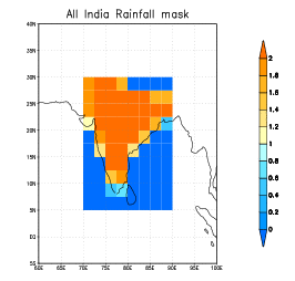
An All India Rainfall index is defined here as a weighted average of rainfall anomalies in the region 5 - 30 N, 70 - 90 E. The weights are proportional to the fraction of low-altitude land in each 2.5-deg. box of the GPCP grid. This fraction is computed from the full-resolution land-sea mask and surface topography of the ERA-Interim dataset, low-altitude points being defined as grid points with surface height less than 1000 m. The low-altitude criterion excludes points corresponding to the mountain regions of Nepal and Tibet. The land fraction is additionally set to 0 over Sri Lanka, values less 0.2 are discarded, and weights are finally normalized to have area average = 1.
Fig8.3.4.3-4: All India Rainfall Index


